Tourism · Travel guide

Giresun Travel Guide

Giresun Travel Guide is a bilingual (Turkish and English) web app we designed and built for anyone who wants to explore Giresun on the Turkish Black Sea coast. It brings 63 stops together on one page: castles, highland plateaus, glacial lakes, waterfalls and places to eat. Visitors see the stops on a map and on an elevation profile, filter them by category and add the ones they like to their route; the app puts the stops in order, works out driving and visiting time, then starts navigation in Google Maps or Yandex with a single tap. There are also local recipes, practical tips, a blog with 53 articles, current news and a separate admin page for visitor suggestions. It works comfortably on phones too.
  • Single-page web app running in the browser
  • Leaflet and OpenStreetMap
  • Google Maps, Yandex and Apple Maps links
  • PHP (suggestion form, suggestions admin, news)
  • Google News feed
  • Turkish and English interface
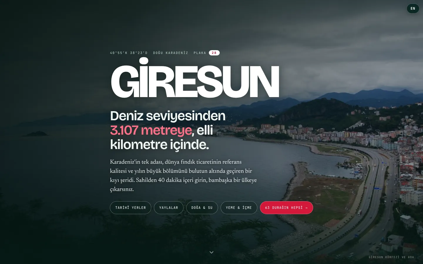
Giresun Travel Guide home screen: title and category buttons over a photo of Giresun bay
Users
Anyone visiting Giresun
Content
63 stops, 9 local recipes, 53 articles
Video
Video and narration in two languages at 25 stops
Route
Orders the stops and estimates the time
Navigation
Google Maps, Yandex, Apple Maps
Languages
Turkish and English

The screenshots were taken from the live site (giresun.collapssi.tr) in read-only mode. The login and list screens of the suggestions admin were rendered locally with the page's own design and fictional sample suggestions (names marked "(örnek)"); the password shown is an example. The flow diagrams were made from these screens.

01

From opening the app to directions in four steps

The guide's main job is to get someone on the road in a few taps. They choose a language, see the stops on the map, add a stop to their route and open their navigation app.

User journey diagram: language choice, map, stop card and navigation choice, with numbered steps and arrows
02

What we built specifically for Giresun

This guide is not an off-the-shelf template; every part of it was built around Giresun's geography, roads and food. Whatever a city or a business needs, we shape the product around it.

  • The elevation profile was drawn for Giresun: from the coast to Karagöl Mountain (3,107 m), with the hazelnut belt, spruce forest, highland bands and Giresun's own fog belt (700 to 1,500 m)
  • Route times were calibrated against real journeys in Giresun, with winding mountain roads and lower speeds taken into account by altitude
  • Giresun Island cannot be reached by road, so navigation leads to Giresun Port, where the boats leave, and the card explains why
  • The Giresun province border is drawn on the map and everything outside it is darkened
  • For 25 stops, two separate video playlists, one Turkish and one English, are linked to the cards with flag buttons, alongside short preview videos
  • Places to eat are grouped the Giresun way (Breakfast & Kuymak, Pide & Yağlama, Fish, Köfte & Grill, Burger, Desserts & Hazelnuts), with Google ratings and review counts
  • 9 local recipes (such as beet-green soup, hamsi with rice, melocan stir-fry and kaygana) with a jump from each recipe to the places that serve it
  • "Four things that gave Giresun its name": cherries, Giresun-quality hazelnuts, the Kuşköy whistled language and the Aksu festival
  • Practical tips specific to Giresun: Ordu-Giresun Airport, fuel and fog warnings for highland roads, and a month-by-month highland chart
  • A 53-article Giresun blog in two languages: 7 district guides plus highland, season and festival articles
  • A news page collecting Giresun news, plus a suggestion form and a password-protected admin page
03

Home screen, language and design

On the first visit, visitors are asked whether they want Turkish or English; the choice is remembered in the browser and can be changed any time with the button at the top right. The home screen shows a photo of Giresun, a short introduction and buttons leading to the categories. The guide is usually opened on a phone, on the road. So every screen was arranged separately for phones, and the look was taken from Giresun's own colours.

  • Türkçe or English, remembered on later visits
  • A TR / EN button always visible at the top right
  • Buttons for historic sites, highlands, nature and water, food and drink, plus "all 63 stops"
  • Full-screen home on phones, with the buttons wrapping onto a second line
  • The category buttons on the home screen filter that category straight away and scroll you down to the stop list
  • A coordinates label (40°55′N 38°23′E, plate 28) and a "from sea level to 3,107 metres" introduction
  • Screen-by-screen scrolling with a down arrow; if the device asks for reduced motion, the animations are switched off
  • Switching language redraws the page without reloading it: the texts of all 63 stops, district names, categories, food types and the 9 recipes all have English versions
  • A compact route bar and buttons that wrap onto a second line on phones
  • While the route bar is open, space is added at the bottom of the page so no card hides behind it
  • A colour language taken from fog, deep green, highland meadows, cherries and hazelnuts
  • Three typefaces for headings, text and numbers (Bricolage Grotesque, Newsreader, JetBrains Mono)
  • A Collapssi signature in the footer
Language window: Türkçe and English buttons
Home screen: Giresun title, introduction and category buttons
Home screen on a phone
04

An elevation profile from sea to highlands

Giresun is best explored by altitude rather than by district, so we show the stops on a profile running from the coast up to Karagöl Mountain (3,107 m). The coloured dots are the stops' elevations; tapping a dot jumps to that stop's card.

  • A curve showing the highest point at each latitude from north to south
  • Bands for the Black Sea, hazelnut belt, spruce forest, highlands and inland
  • A marker for the fog belt (700 to 1,500 m)
  • Stop dots in category colours that lead to the card
  • Hovering over a dot shows the stop's name and elevation
  • Clicking a dot, or pressing Enter on the keyboard, opens the card and makes it glow briefly
  • Dots that fall very close together are nudged sideways so they never overlap; a Karagöl summit marker and a metre grid
Elevation profile: curve from the coast to Karagöl Mountain with stop dots
05

Everything on one map

All stops appear on one map with colour-coded markers. The Giresun province border is drawn and everything outside it is dimmed, so it is easy to see which stops are close to each other. Tapping a marker opens a bubble from which directions can be started.

  • Leaflet with OpenStreetMap, zoom and pan
  • Categories with counts: history and heritage, highlands, nature and water, town and coast, living culture, food and drink
  • Show or hide categories on the map
  • Province border line with the outside dimmed
  • Directions with Google from the marker bubble
  • A "Show on map" box: the province border can be switched on and off too, and "Show all" resets everything
  • The map is centred on the province border when it opens
  • Mouse-wheel zoom is off, so scrolling the page never gets caught by the map
  • If the map tiles do not arrive within 6 seconds, visitors are told they can still start navigation from the cards
Map: colour-coded stop markers within the Giresun province border and the category list beside it
06

Stop list and cards

Below the map the stops are listed as cards. A sticky filter bar sits on top: several categories can be selected at once, places can be searched by name, district or keyword, and the list can be sorted. If visitors allow location access, every distance is measured from where they are.

  • Each card shows a photo, category, elevation, district and distance, a short highlight and a description
  • Duration, fee and tip rows, plus a warning when needed
  • Photos for all 63 stops
  • On 25 stops, a short silent looping video on the card; the photo stays as the cover, and the video comes in two formats so it plays in every browser
  • On the same 25 stops, Turkish and British flag buttons over the photo open Turkish and English narration videos on YouTube
  • If a photo cannot load, a small mountain drawing marking the stop's elevation is drawn automatically
  • Sorting: recommended, elevation, name and nearest to me
  • "Use my location" for personal distances and "Build a route with 4 nearby stops" for a ready route
  • Copy the coordinates with one tap
  • 63 stops: 21 history and heritage, 7 highlands, 8 nature and water, 9 city and coast, 1 living culture, 17 food and drink
  • Search looks at names, districts, descriptions and food types, and handles Turkish letters correctly
  • If location access was granted before, it is not asked again; if it was refused, the app explains how to turn it on
Stop cards: filter bar, location prompt and the Giresun Castle, Giresun Island and Giresun Museum cards
Filters and the Giresun Castle card on a phone
07

Route planner

Stops added with the "+" button on the cards gather in a route bar at the bottom of the screen. The app arranges them in the order with the least travel, lists the distance and time of each leg and the visiting time of each stop, and says when the day will end.

  • Number of stops, starting point (Giresun centre or your location) and total time
  • Travel time and visiting time shown separately
  • Walking time for short legs, driving time for longer ones
  • A day plan: "Leave at 09:00 and you will finish around ..."
  • "Open in navigation" puts the whole route on the map; Google Maps takes at most 10 stops per route, so the first 10 are used
  • A note explaining that times are estimates and how they are calculated
  • The shortest order is found in two steps: always go to the nearest stop next, then try reversing parts of the order to find a shorter one
  • Driving time is worked out from straight-line distance; the higher the stop, the bigger the allowance for winding roads and the lower the average speed, plus time for parking
  • Times were calibrated against real journeys in Giresun: Giresun to Kümbet about 1.5 hours, to Şebinkarahisar about 2 hours, to Tirebolu about 45 minutes
  • Visiting time comes from each stop's details (half day 1.5 hours, full day 2.5 hours); for places to eat it depends on the type (breakfast 60 min, burger 25 min and so on)
  • A colour-coded day plan: short half-day tour, relaxed day, full day or "this will not fit into one day, split it over two"
  • If the starting point is outside the province (more than 250 km away), the first leg is left out of the total with the note "getting to Giresun is not included"
  • "Build a route with 4 nearby stops": puts the 4 stops closest to you and to each other, within the chosen categories, into the route
Route programme: three stops, distances and times between them, total time and day plan
Route programme on a phone
09

Giresun's table, food and drink, and practical tips

The guide also covers what makes a trip richer: recipes, ingredients and seasons for nine local dishes, the stories behind the city's name, and sections on getting there, the best time to visit and small warnings. When the food and drink category is selected, a second filter opens above the list. Food cards differ from sightseeing stops: instead of elevation they show a rating, and instead of duration and price they show what to eat and opening hours.

  • Sub-filter: Breakfast & Kuymak, Pide & Yağlama, Fish, Köfte & Grill, Burger, Desserts & Hazelnuts, each with its number of places
  • Google rating and review count on the card
  • A "what to eat" line and opening hours
  • Places to eat can be added to the route too; the route allows sitting time by type
  • Nine local dishes: season label, ingredients, method and where to eat them ("Open recipe")
  • "Four things that gave Giresun its name": cherry, hazelnut, whistled language, the Aksu festival
  • Getting there, a month chart for when to go, cuisine and small warnings
  • Each recipe card has ingredients, step-by-step method and a nutrition note
  • "Where to eat it" buttons lead to the card of the place where that dish is served
  • Getting there: Ordu-Giresun Airport, the Trabzon option, car hire and a fuel warning for highland roads
  • A 12-month "when to go" chart
Giresun cuisine: dish cards with season labels and Open recipe buttons
Practical tips: getting there, when to go, cuisine and small warnings
10

Blog, news and search engines

A blog of 53 articles that give background to the stops, and a news page that gathers current travel, highland and event news from Giresun, are linked to the guide. News is fetched on the server from Google News and kept for a short time so the page opens quickly. Every page was prepared so that search engines can read it and Google can find the guide. Visitors never see these parts, but they decide how the site appears in search results.

  • Blog topics: getting started, highlands, nature and water, history and culture, districts, food and shopping
  • Reading time and elevation range on each article
  • News: source, time and a link to the article
  • 53 Turkish and 53 English articles, each on its own address
  • 7 district guides (Bulancak, Dereli, Espiye, Görele, Şebinkarahisar, Tirebolu, Yağlıdere) and "who is it for" articles
  • Article pages show the update date, a strip with the article's elevation range, month-by-month tables and a "what to pack" list
  • A "Plan a route" box leads back to the map guide, and "Read next" suggests related articles
  • Relative times in the news, such as "9 hours ago"
  • A title, description, canonical address and a share card (Open Graph, Twitter) on the home page
  • Structured data describing the site and Giresun as a destination (WebSite, TouristDestination)
  • A sitemap with 110 addresses; every page is listed together with its Turkish and English counterpart (hreflang)
  • Article, place and breadcrumb structured data on blog posts
  • Separate pages aimed at searches such as seasons, festivals, cafés, viewpoints, camping, hiking and travelling with children
Blog page: 53 articles about Giresun and topic buttons
News page: current Giresun news with source and time
11

How the admin screen opens: suggestion form and suggestions admin

The "Send a suggestion" button at the bottom of the guide opens a form where visitors can report a missing stop, a mistake or a place they would like added. Suggestions can only be read on an admin page protected by a password. There is no link to this page on the site; the administrator opens the /oneri-yonetim address, enters the password and sees the list.

  • Suggestion form: name and email optional, in Turkish and English
  • The admin page is protected by a single password and hidden from search engines
  • Newest suggestions first: date, language (TR / EN), name and email
  • Reply by email with one tap, then Log out
  • Suggestions can be up to 4,000 characters; an invisible trap field that only bots fill in filters out spam
  • The suggestion form is also hidden from search engines
How the suggestions admin opens: a visitor sends a suggestion, the administrator logs in with a password and sees the list, in numbered steps
Suggestion form: name, email and message fields
12

The same structure for all of Türkiye

We have also carried the map-based guide, route planner and one-tap navigation we built for Giresun over to a Türkiye Travel Guide version covering all 81 provinces, with region, province, theme and route pages generated the same way. The page generation for this version is ready; putting it online is the next step.

  • 81 province guide pages and 7 region pages
  • Theme pages (UNESCO, ancient cities, beaches, waterfalls and more)
  • The same route planner and navigation menu
  • 18 recipes and 13 ready-made routes
  • A clickable province map and a west-to-east elevation profile
  • A multi-day route planner
  • While the pages are built, every stop's coordinates are checked to be inside its own province

Planning a similar project?

Tell us what you need; we will define the scope, timeline and cost together. The first consultation is free.

Tell us about your project